Harihar for Trekking : One Of The Amazing Experience

HISTORY OF HARIHAR FORT :
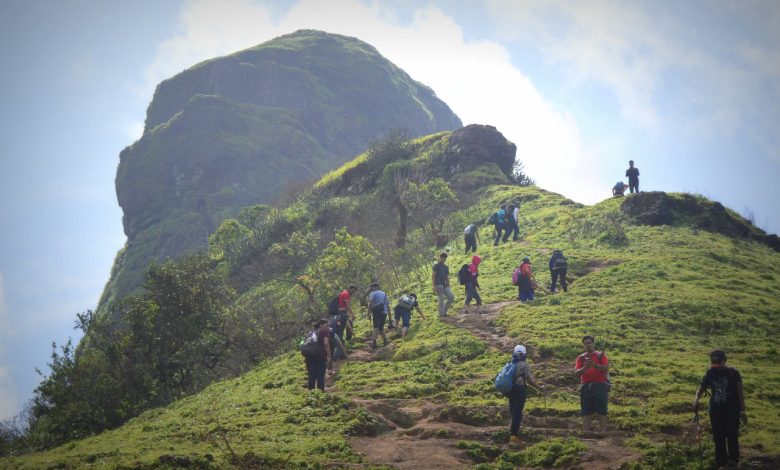
Harihar Fort or some might know it by Harshagad is fort which is situated in Nashik district in Trimbak Fort range which was built During the Yadava Dynasty. The main purpose of the fort was to keep an eye on the trade route of Nashik. Later on, incoming centuries, The fort went under several kingdoms. Now the fort is in ruins. It is said that, During the British rule, the fort was to be destroyed, but the captain fell mesmerized watching the carved steps in the mountains. So the fort was left on its on. Harihar Fort also known as “Harish Fort” lies in the trimbakeshwar range, is at a height of 3676 ft above sea level. The fort appears to be rectangular from its base village and is located on top of a triangular massif with all the three sides being vertical.
One has to reach the fort through a 200 ft high rock cut staircase inclined at an 80-degree angle.
How to reach:
I along with my 7 other mates from Gujarat registered for this one-day trek with Trek Mates India. All the trekkers (33 of us) reached the meeting point at Dadar, Mumbai, from where we took an overnight bus at around 12:00 PM and reached the base village early by 6:00 am.
Via Kasara or Nasik :
One can reach Igatpuri via Kasara or Nasik. From Igatpuri board in a bus for Trimbakeshwar and alight at Nirgudpada, the base village of Harihar.
Via Igatpuri –>Trimbakeshwar –> Khodala :
Ahead of Nirgudpada lies the village of Kasurli. One can reach here by boarding the bus of Igatpuri ->Trimbakeshwar -> Khodala.
Best time to visit :
Monsoon time is best as the views are awesome, but one have to be super cautious while climbing the ladders.
Time and Scale :
The trek can be covered in one day. The time required is a maximum of 3 hours each way, reaching the hill and descending back to the village.
Though the hill looks difficult, it can be rated as a medium trek.
The Trek to Harihar Fort:
The trek to the Harihar gad you see below is simple and easy, but one has to be a little careful while climbing up as well as descending. The reverse descend is suggested here because the steps are very steep. There are grooves in the ladders for grip, which are very useful for both ways.
We had our breakfast at the base village at around 7-7:30 am. After the introduction we started from the village, soon we reached a point with a small kund and a shivji temple which is a good resting zone. The hill point is the main thrill of the trek.
There are more than 100 ladders here and only one person can walk at a time, you have to make space for people to get down,
actually stop for a while as it gets difficult for two people at one time to cross.
Once you cross the ladders, you reach the rocky phase where you will get to see some breathtaking mountain views. We reached the top and spent some time getting our free fish pedicure. We searched for some shade beneath a tree and made it our lunch point.
The Gujju Gang had some great food and chatnis to add more to the memories. Post lunch we explored the top and crossed a little valley of flowers zones to reach at the top of a small rock where we had some great groupies.
Alert:
I don’t recommend this trek for first-time trekkers, especially if they have a height phobia.
There is no facility of water or food once you cross the village during the trek, except at one point just when you start to climb the hill, where villagers sell some biscuits, and you may also get water. After that point, if you are short of water, you need to get it from the running streams.
How to get there??
Base village-1) Nirgudpada/Kotamvadi
(Located approx 48 KM from Igatapuri as well as Nashik)
2)Harshewadi
(Located 13 KM from Trymbakeshwar)
Recommendation-Harshewadi route is more easier than Nirgudpada/Kotamvadi.
Location from Mumbai to Base Village – (approx 190 KM )https://goo.gl/maps/uN2iWjogKDx
Location from Pune to Base Village – (approx 250 KM)
https://goo.gl/maps/7KjwxbdzVxR2
Height: – 3676 feet
Famous for – Peculiar rock-cut steps,
There are no good structures left on the fort except for a storage house with a small entrance, There is a series of rock-cut water cisterns in the centre of the fort. It takes about an hour to visit all places on the fort.
Grade: – Difficult.
Endurance level: – High
Time Required for climbing : – 3.5-4 hours.
What to Bring-
-Minimum 3 lit water.
-Ready to eat food.
-Some snacks & biscuits.
-Glaucon powder.
-Extra Pair of clothes.


